top of page

UPGPR Locating Service

Ensuring Safe and Reliable Underground Locating

About UPGPR Locating

Who We Are

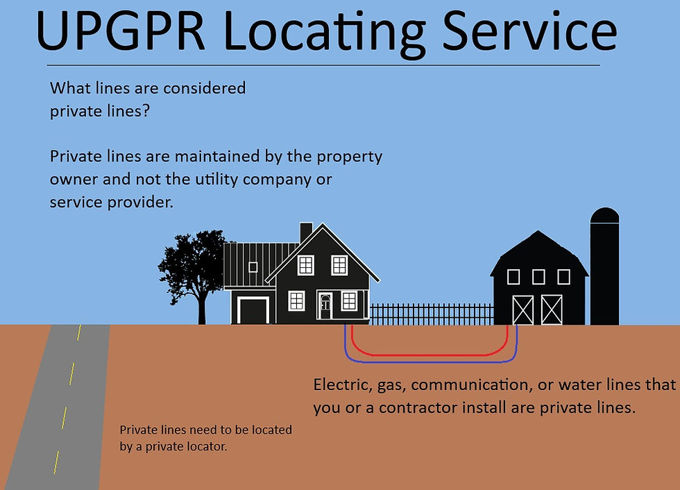
UPGPR Locating is a private underground locating service located in Delta County, Michigan, dedicated to providing high-quality and reliable locating solutions for various PRIVATE underground utilities. With a focus on precision, professionalism, and client satisfaction, we offer a wide range of locating services tailored to meet your specific needs. Approximately 700,000 underground utility lines are struck annually. The Miss Dig Underground Facility Damage Prevention and Safety Act went into effect in 2014 requiring all excavators to call 811 before digging. However, this only applies to public utilities. Miss Dig does not locate PRIVATE utilities. We have top of the line locating equipment, and the education to use it from completing GPR and EM locator classes at Staking University in Manteno Illinois.   With the use of our EM locator for locating conductive utilities, and our Ground Penetrating Radar unit for non-metallic pipes and underground objects. 

private locate.jpg

What We Offer

At UPGPR Locating, we offer underground locating services designed to ensure the safety and integrity of underground infrastructure. 

UPGPR Locating Services

IMG_EM.JPG

EM Locating

Underground utility strikes are dangerous and expensive, and the job of a utility locator is to reduce the likelihood of a strike to as close to zero as possible. The key to safely locating utilities before excavating is to combine multiple locating tools in the proper way. Using a combination of Electromagnetic (EM) Locators, Ground Penetrating Radar (GPR) and Magnetic Locators provides a more complete locate and minimizes utility strikes.

GPR Locating

Whether it's underground utilities, pipelines, or cables, we have the ability to accurately locate and map underground assets with precision and care. This is our GPR unit being used to locate multiple conduits and electrical lines crossing a concrete driveway. 

GPRpic_edited_edited.jpg

Ground Penetrating Radar

Understanding GPR

Using Ground Penetrating Radar (GPR) to scan for underground objects can aid in finding objects that traditional radio detection methods cannot locate. We charge $150/hr. with a 2-hour minimum for GPR service.  Common uses for GPR surveys are scanning for buried utilities, locating Underground Storage Tanks, identifying potential grave site or artifact location, scanning for rebar or objects under a rebar reinforced concrete slab, and to look for disturbances in native soil such as the location of a hole or trench. The GPR machine needs constant contact with the ground and must go over an area to scan it. So, it can’t be used to scan directly next to any obstacles, trees, steps, and any non-smooth ground area. It can work through concrete but will not work through any wood decking or raised platform. While GPR is valuable in ways other tools cannot be it cannot do everything and has its own limitations.

The limiting factors for GPR use are access to the site, ground and soil type, and the object to find. Soils with lots of clay or high in water lower the penetration depth. Lots of rocks increases interference and creates spot objects. The pathway must be clear for some feet in every direction. The target area must be flat enough to easily move the low-to-the-ground GPR machine across it. Even then, GPR scanning is time consuming, and we need multiple passes to eliminate false positives.

​The stronger the contrast is then the greater the reflection will be and hence the better signal the GPR machine will display. A shallower object will reflect stronger than a deeper object. There comes a depth that the radar loses coherence, and reflections won’t make it back to the GPR to be measured.

Due to the complex nature of subsurface investigations there is no guarantee about finding or not finding anything. The information obtained from a GPR survey is best used in combination with other data. This means things such as site maps, historical trends, on-site indicators, and records.


EM Locating

Electromagnetic Locating

EM Locators are the most common locating tool. Technically, these locators do not locate cables or pipes directly; they locate the EM field around the utility. This can be performed passively, or actively. 

An electromagnetic locator consists of a transmitter, which sends out signals, and a receiver, which receives the frequencies reflected by objects that are metal or a conductive material.

Private utility EM locating includes things like power lines, metal pipes (e.g. water and gas pipes), tracer wires, conduits that our traceable rod can go down, and communication lines. See our authorization form for limits. If you need to do some utility recon we can help locate lines with precision.

UPGPR Locating, LLC can locate anything that is traceable.

 Powered and secured by Wix

bottom of page